

Recently updated on August 7th, 2025 at 03:19 pm
The arrival of the interstate revolutionised the way Americans get around this enormous country. On 29 June 1956, President Eisenhower signed the Interstate Highway System into existence through the Federal Aid Highway Act. It set off a colossal engineering feat that changed road transportation forever in the US.
This massive country-wide road network currently stands at around 47,850 miles in length. It’s filled with great views and good pavement, so you can see the best of the country in style on one of Trafalgar’s holidays to the USA. Whether you want to cruise through the Deep South, wind your way up the Atlantic Coast, or take on the big road trip from East to West, here are 7 of the best interstate travel routes in the USA.
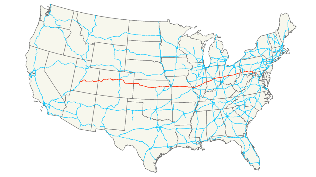
1. Interstate 90: Seattle to Boston

Interstate 90 is the longest you can take on in the nation, crossing 13 states and 3,085 miles. It starts near Safeco Field in Seattle then passes through a tunnel under Mount Baker Ridge, listed on the National Register of Historic Places. As you leave Seattle, you’ll cross two floating bridges, including Evergreen Point Floating Bridge, the longest and widest floating bridge in the world.
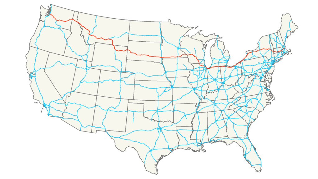
You’ll then cross the scenic Lake Washington before continuing through places like Wallace in Idaho where the Battle of the Little Bighorn took place. Make a stop in the city of Cleveland, before reaching the end near the Logan International Airport in historic Boston.
RELATED CONTENT: Everything you need to know about travelling between states in the USA
2. Interstate 95: Miami to Houlton, Maine

I-95 may not be the longest interstate, but it covers the most states in the country, spanning 1,920 miles through 15 states plus the District of Columbia. This massive road takes you from the sunny shores of Miami to the cooler town of Houlton in Maine on the US-Canada border.
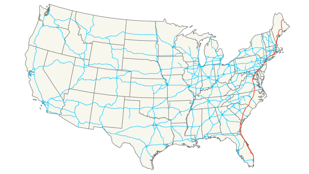
You’ll drive through the eastern greats of Miami, Baltimore, Washington D.C., Philadelphia, New York and Boston. Cruise along the Atlantic Ocean, before dipping inland through Georgia, Virginia and the Carolinas. You’ll finish by humming through the gorgeous region of New England, including New Hampshire and your final stop, Maine.
GET INSPIRED BY: East Coast USA and Canada End New York
3. Interstate 80: San Francisco to Teaneck, New Jersey

Route 66 may be the most iconic path for an east-to-west road trip. But the I-80 takes the crown as the best interstate travel route through the middle of the USA, passing 11 states and 2,902 miles.
You’ll begin in the heart of San Francisco at Bay Bridge, crossing the Bonneville Salt Flats near the Great Salt Lake, and hitting parts of the California Trail in California and Nevada. Next up, you’ll climb to 8,000 feet above sea level in Wyoming and cover parts of the Oregon Trail through Wyoming and Nebraska.
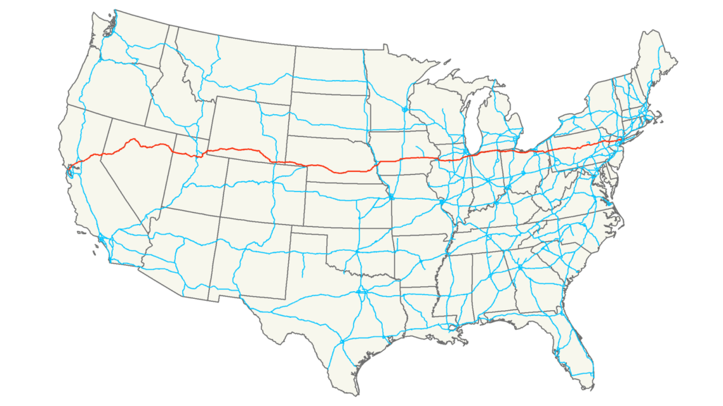
You’ll then have a virtually straight 72-mile run outside of Lincoln, Nebraska – the longest of all US interstates. After that, you’ll get to explore some of the lesser-visited states like Iowa, Indiana and Ohio. Leaving the pretty cornfields behind, you’ll move through the cosmopolitan stars like Chicago and Cleveland, before ending your journey in Teaneck, New Jersey, just a few miles shy of New York City.
GET INSPIRED BY: Journey Along California’s Pacific Coast Highway
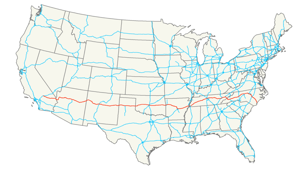
4. Interstate 20: Florence, South Carolina to Kent, Texas
Interstate 20 is the route to take through the southern United States, stretching 1,539 miles across six states. Starting in Florence, South Carolina, I-20 will take you on a journey through Southern culture and history. As you head west, you’ll pass through Atlanta, Georgia, a bustling metropolis with historic landmarks like the Martin Luther King Jr. National Historical Park.

Continuing into Alabama, you’ll get a scenic passage through rolling hills and dense forests before reaching the city of Birmingham. Here, history enthusiasts can visit the Birmingham Civil Rights Institute to learn about the city’s pivotal role in the Civil Rights Movement. Crossing the Mississippi River at Vicksburg, you’ll encounter significant Civil War sites and the picturesque riverfront.
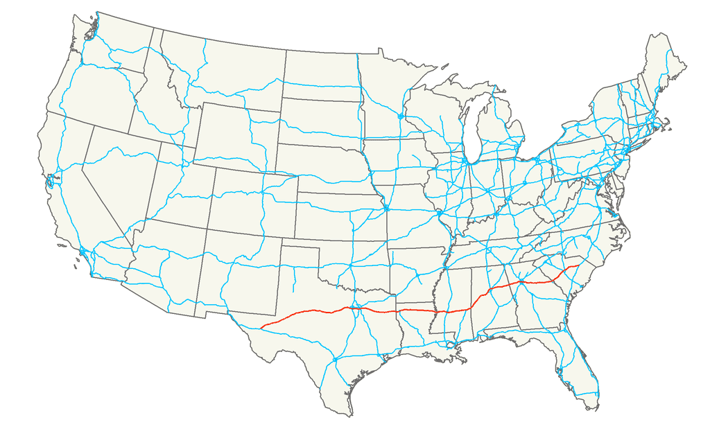
As I-20 traverses Louisiana, the landscape transitions to bayous and swamps, with a must-see stop in Shreveport, known for its lively casinos and cultural festivals. Entering Texas, the interstate cuts through the heart of the Lone Star State. In Dallas, you can explore the Sixth Floor Museum at Dealey Plaza, dedicated to the legacy of President John F. Kennedy. The journey concludes in the quaint town of Kent, Texas, offering a peaceful end to a road trip filled with diverse experiences and unforgettable sights.
You may also like: March in their footsteps: The powerful Trafalgar tour that traces America’s Black History
5. Interstate 10: Los Angeles to Jacksonville, Florida

While the I-80 takes the more picturesque, pastoral route through the middle of the United States, Interstate 10 is all about travelling coast to coast through the American South. It spans 2,460 miles, starting on the shores of Los Angeles at the iconic Santa Monica Pier. It then winds its through eight states including Arizona, New Mexico, Texas, Louisiana, Mississippi and Alabama.
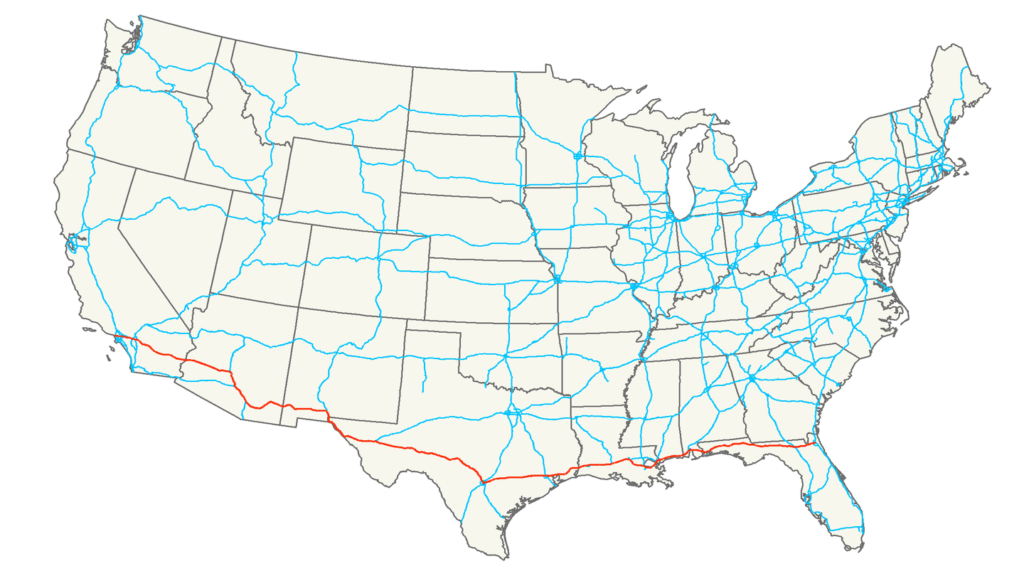
You’ll journey through flat desert roads, cruising from 5,000 feet to below sea level as you hop between famous cities like Tucson, El Paso, Phoenix, Houston and Mobile. You’ll then pass by Lake Pontchartrain into New Orleans, where you’ll cross the six-mile causeway known as the Twin Span Bridge. You’ll end your boot-scootin’ trip on the beaches of Jacksonville in Florida.
GET INSPIRED BY: San Diego, Palm Springs and Orange County Beaches
6. Interstate 29: Kansas City, Missouri to Pembina, North Dakota
Cut right through the center of the United States with Interstate 29, taking you north-south covering 755 miles across four states. Beginning in Kansas City, Missouri, I-29 takes travelers through the heartland of America, passing by the scenic Missouri River and fertile farmlands. As you head north, you’ll pass through Sioux City, Iowa, known for its rich history and cultural attractions, including the Sioux City Public Museum.
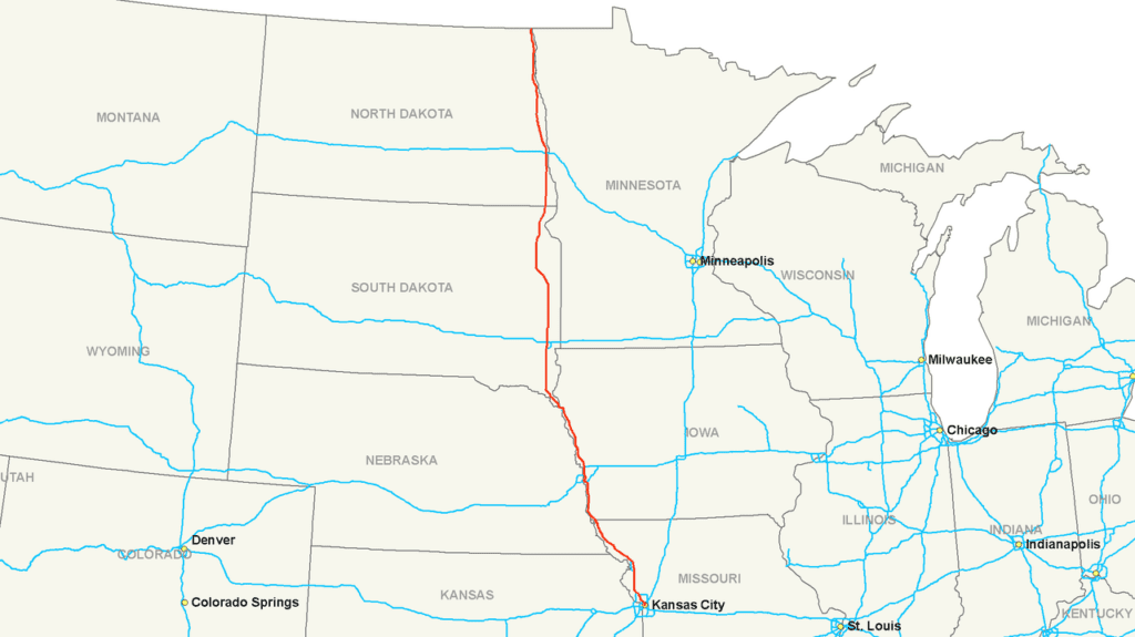
Further along in South Dakota, the route is a gateway to American natural beauty with the Lewis and Clark Recreation Area near Yankton, perfect for outdoor enthusiasts. Continuing into North Dakota, I-29 passes through the vibrant city of Fargo, home to a lively arts scene and the Fargo Air Museum.

The interstate culminates in Pembina, a small town near the Canadian border, offering a serene conclusion to a journey filled with Midwestern charm and scenic vistas.
Discover the Dakotas with Trafalgar on National Parks and Native Trails of the Dakotas
7. Interstate 40: Barstow, California, to Wilmington, North Carolina

Interstate 40 also cuts through the middle of the USA, but this route starts at a junction of pioneer trails at the city of Barstow in California’s Mojave Desert. From there, it’s 2,500 scenic miles to the end at Wilmington in North Carolina. Wilmington is a port city gateway to the Cape Fear Coast beaches and Cape Fear River where the Battleship of North Carolina is moored.
Between Barstow and Wilmington, you’ll see plenty of iconic sights like Oklahoma City, historic Little Rock, and Albuquerque where you can go to the famous balloon festival. You’ll also tap your toes from Nashville, the home of country music, to Memphis, home of the blues. The most scenic part of this interstate travel route takes you to the South Rim of the Grand Canyon. You’ll also get your kicks along Route 66 for the western part of the journey.
GET INSPIRED BY: Southwest Native Trails with Albuquerque Balloon Fiesta
8. Interstate 77: Columbia, South Carolina to Cleveland, Ohio
Interstate 77 is a fascinating north-south route through the eastern United States, spanning 610 miles across five states. Starting in Columbia, South Carolina, I-77 takes you north through Charlotte, North Carolina, a bustling city known for its thriving arts scene and NASCAR Hall of Fame.

Continuing into Virginia, the route crosses the picturesque Blue Ridge Mountains, offering stunning vistas and opportunities for hiking and exploration in the Jefferson National Forest. As you enter West Virginia, I-77 takes you through the state’s rugged terrain, with a notable stop in Charleston, the state capital, known for its historic Capitol building and vibrant riverfront.
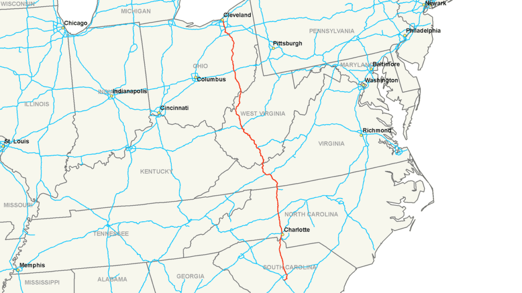
Finally, as you approach Ohio, the interstate passes through the scenic Appalachian foothills before reaching the city of Cleveland. Here, you can explore the renowned Rock and Roll Hall of Fame and enjoy the city’s rich cultural and sports scenes, providing a dynamic conclusion to a beautiful journey.
9. Interstate 70: Cove Fort, Utah, to Baltimore, Maryland

The I-70 contains the oldest section of all US interstate travel routes in Kansas and Missouri. It’s also got one of the most recently built sections of any interstate, with the last stretch finished in 1992. The route starts in Cove Fort in Uth and runs for 2,175 miles through 10 states including famous cities like Denver, Kansas City, Indianapolis, St. Louis, Columbus, Pittsburgh and Baltimore.
Along the way, you’ll come across highlights like the Eisenhower Tunnel, the highest vehicular tunnel in the world. It’s also the highest point in the whole USA interstate system at 11,158 feet. You’ll cross quite a bit of history, as the I-70 was the first interstate to go through previously uncharted territory in Utah’s San Rafael Swell. It also has the longest stretch of interstate without any services. You’ll definitely want to stock up snacks before you take on this interstate road trip!
GET INSPIRED BY: America’s Amazing Canyon Country
10. Interstate 75: Miami to Sault Sainte Marie, Michigan

If you want to take an epic journey through America’s Southeast, take the I-75. It starts in Miami and crosses six states over 1,787 miles, ending in Sault Sainte Marie near the US-Canada border. You’ll pass through Georgia, Tennessee, Kentucky and Ohio, with stops in buzzing cities like Atlanta, Chattanooga, Lexington and Cincinnati.
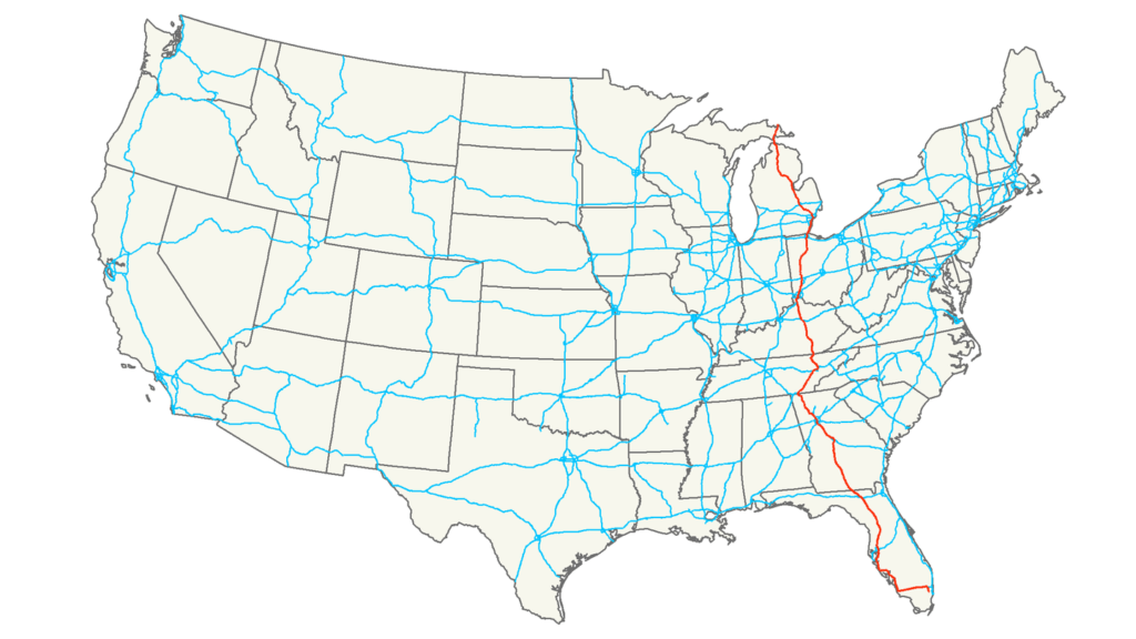
You’ll also get a taste of America’s natural beauty, as you pass over the Cumberland Mountains and follow the shore of Lake Erie to Detroit. Once you get to Michigan, you’ll get to cross the star of I-75, Mackinac Bridge. This impressive 26,000-foot-long bridge is the longest suspension bridge in the Western Hemisphere.
GET INSPIRED BY: Spirit of the South
11. Interstate 5: San Diego, California to Blaine, Washington
Take a West Coast road trip on Interstate 5, the major north-south route taking you from California to Washington spanning 1,381 miles through three states. Starting at the Mexican border in San Diego, California, I-5 offers travelers a journey through some of the most diverse and scenic landscapes in the United States. As you head north, you’ll pass through Los Angeles, the entertainment capital of the world, where you can stop by iconic attractions like Hollywood, Beverley Hills and Disneyland.

Continuing through California, I-5 traverses the fertile Central Valley, known for its vast agricultural fields and charming small towns. As you approach Northern California, the route takes you through Sacramento, the state capital, rich in Gold Rush history and vibrant cultural heritage. Further north, you’ll encounter the stunning landscapes of Mount Shasta and the Shasta-Trinity National Forest.
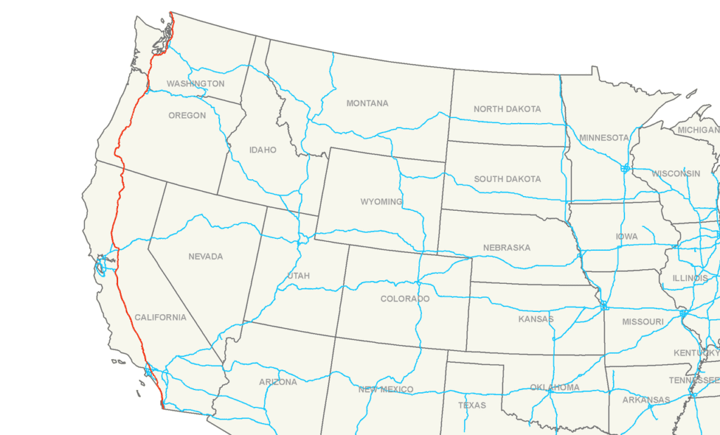
Entering Oregon, I-5 passes through the lively city of Portland, famous for its unique culture, craft breweries, and beautiful parks. The journey continues through the lush greenery of the Willamette Valley and up into Washington. In Washington, you’ll travel through Seattle, a city renowned for its tech industry, iconic Space Needle, and vibrant waterfront. The interstate concludes in Blaine, at the Canadian border, finishing off your West Coast adventure.
Highway safety
Don’t forget to stay safe when driving along these iconic, scenic routes. Find all the details you need about intersection safety, speed management, rural road safety and more from the Federal Highway Administration.
Are you dreaming of an interstate trip? What is your favourite interstate travel route in the USA? Let us know in the comments below! For more epic journeys across the USA, take a look at our new Near Not Far Limited Series of trips.